

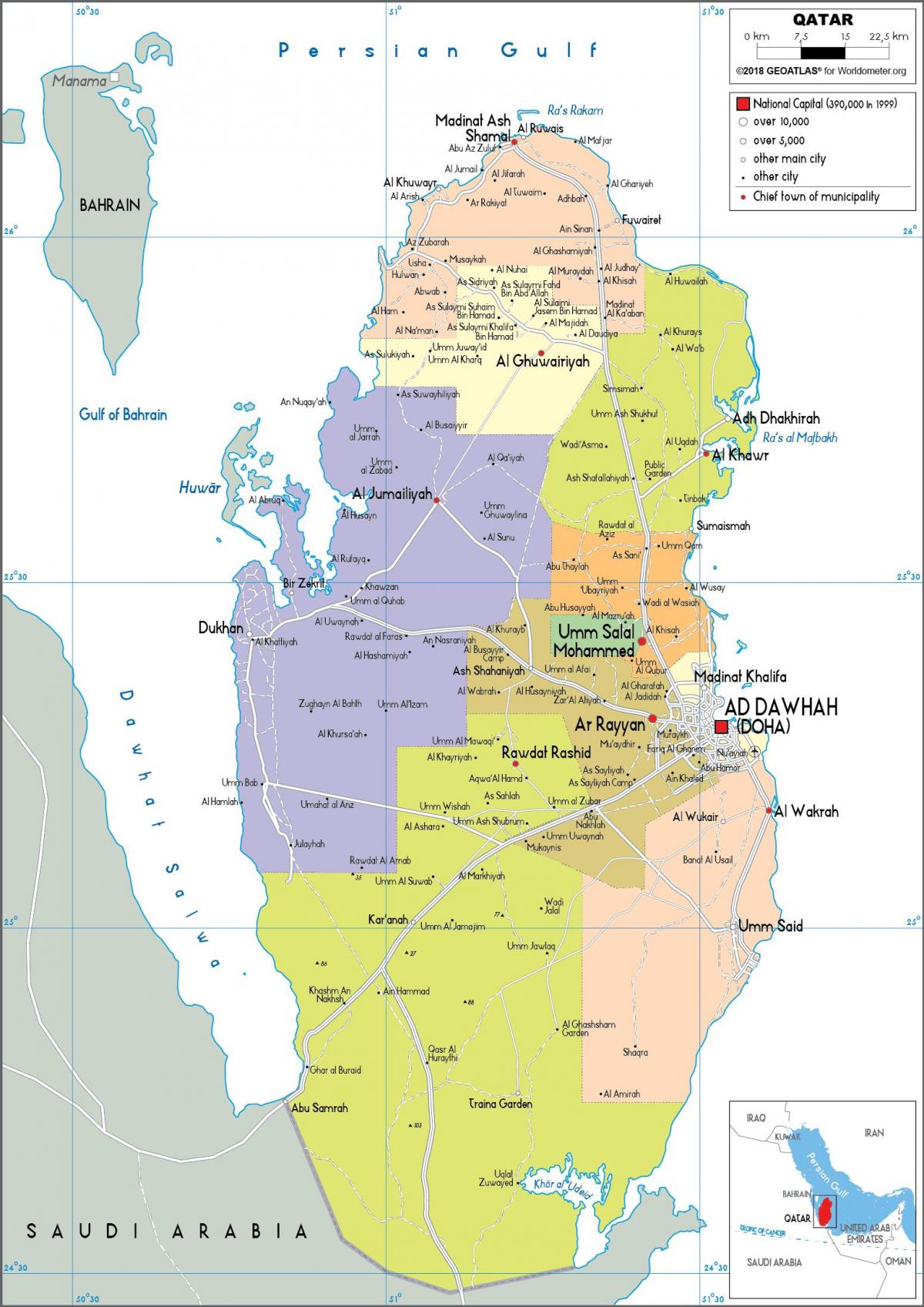
You can find on this page the Qatar region map to print and to download in PDF. The Qatar political map presents states, regions, provinces and surrounding areas of Qatar in Western Asia.

The Qatar regions map shows surrounding areas and provinces of Qatar. This administrative map of Qatar will allow you to know regions of Qatar in Western Asia. The Qatar regions map is downloadable in PDF, printable and free.
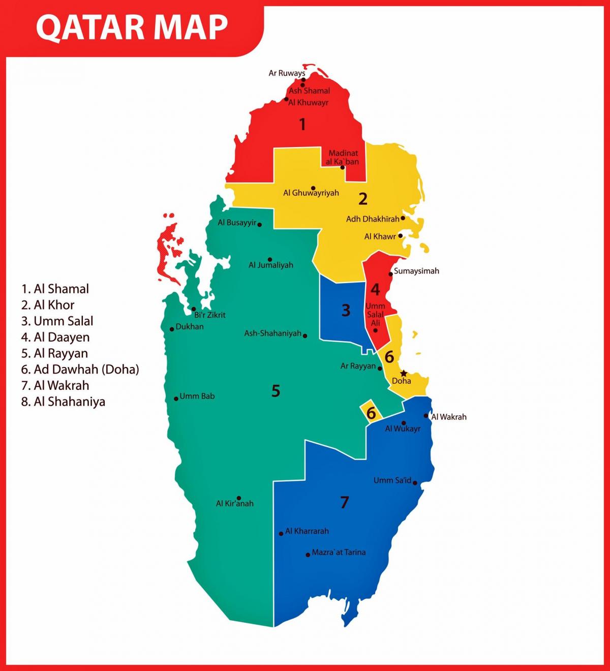
Before 2004, Qatar was divided into 10 municipalities (baladiyah): Doha (Ad Dawhah) الدوحة, Al Ghuwariyah الغويرية, Al Jumaliyah الجميلية, Al Khawr الخور, Al Wakrah الوكرة, Ar Rayyan الريان, Jariyan al Batnah جريان الباطنة, Madinat ash Shamal الشمال, Umm Salal أم صلال, Mesaieed مسيعيد. Since 2004, Qatar has been divided into seven municipalities. A new municipality, Al Daayen, was created under Resolution No. 13, formed from parts of Umm Salal and Al Khawr; at the same time, Al Ghuwariyah was merged with Al Khawr; Al Jumaliyah was merged with Ar Rayyan; Jarayan al Batnah was split between Ar Rayyan and Al Wakrah; and Mesaieed was merged with Al Wakrah as you can see in Qatar regions map.
According to Ministry of Municipality and Urban Planning, in year 1963, the first municipality was the Municipality of Qatar, created under Law No. 11. Later in the same year, its name was changed to Municipality of Doha by Law No. 15. Then, in 17th of July 1972,Ar Rayyan, Al Wakrah, Al Khawr and Dhekra, Ash Shamal, and Umm Salal municipalities created under Resolution No.11. In 1997, Umm Sa'id municipality formed from parts of Al Wakrah (former HASC code QA.WA, FIPS code QA05) and Jariyan al Batnah (QA.JB, QA07). In 2004, Al Daayen municipality created under Resolution No. 13. Judging from maps of the municipalities before and after this change, Al Daayen was formed from parts of Umm Salal and Al Khawr; at the same time, Al Ghuwariyah merged with Al Khawr; Al Jumaliyah merged with Ar Rayyan; and Jarayan al Batnah was split between Ar Rayyan and Al Wakrah. According to the Ministry of Municipality and Environment, Qatar Municipality was the first municipality in Qatar that was established in 1963 as its shown in Qatar regions map. It was later changed to Doha Municipality in the same year. Al Rayyan was created as an independent municipality or region under the Ministry of Municipality and Urban Planning in 1972.
Established in 1972, Umm Salal translates to "mother of rocks" since "Umm" is mother while "Salal" refers to rocks or stones. It was named after the numerous rock formations found in the area. Also established in 1972, the municipality sits on the northeast coast of the country and was ruled by the Al Muhannadi, a tribe composed of several Bedouin families. Al Khawr means "bay" and is also the name of the municipal seat, which was near a bay. Al Wakrah was initially a small pearling and fishing village. The municipality was established in 1972, along with four other municipalities. Al Daayen municipality is the seventh municipality to be established in Qatar and was created in 2014. Located in the northernmost part of the country as its mentioned in Qatar regions map, Al Shamal is also the least populated municipality in Qatar. Shamal means 'north' in Arabic and its capital city is Madinat ash Shamal. Once a part of Al Rayyan, Al Sheehaniya was split off in 2014 to form its own region. It got its name from a plant known locally as 'sheeh' which was valued for its anti-inflammatory effects.

The Qatar political map shows regions and provinces of Qatar. This administrative map of Qatar will allow you to show regions, administrative borders and cities of Qatar in Western Asia. The Qatar political map is downloadable in PDF, printable and free.
The political system of Qatar is an absolute monarchy, with the Emir of Qatar as head of state and head of government as you can see in Qatar political map. Under the 2003 constitutional referendum it should become a constitutional monarchy. In November 2011, Emir Hamad bin Khalifa Al Thani announced the first legislative election to take place in 2013. In Qatar, the ruling Al Thani (ال ثاني) family continued to hold power following the declaration of independence in 1971. The head of state is the Emir, and the right to rule Qatar is passed on within the Al Thani family. Politically, Qatar is evolving from a traditional society into a modern welfare state. Government departments have been established to meet the requirements of social and economic progress. The Basic Law of Qatar 1970 institutionalized local customs rooted in Qatar conservative Islamic heritage, granting the Emir preeminent power.
The Emir role is influenced by continuing traditions of consultation, rule by consensus, and the citizen right to appeal personally to the Emir as its mentioned in Qatar political map. The Emir, while directly accountable to no one, cannot violate the Sharia (Islamic law) and, in practice, must consider the opinions of leading notables and the religious establishment. Their position was institutionalized in the Advisory Council, an appointed body that assists the Emir in formulating policy. There is no electoral system. Political parties are banned. The influx of expatriate Arabs has introduced ideas that call into question the tenets of Qatar traditional society, but there has been no serious challenge to Al Thani rule. In February 1972, the Deputy Ruler and Prime Minister, Sheikh Khalifa bin Hamad, deposed his cousin, Emir Ahmad, and assumed power. This move was supported by the key members of Al Thani and took place without violence or signs of political unrest.
The Consultative Assembly (Majlis as-Shura) has 35 appointed members with only consultative tasks. It is not elected; it is not democratic. However, the 2003 Constitution of Qatar calls for a 45 member elected Legislature, which is to be made up of 30 elected representatives and 15 appointed by the Emir as its shown in Qatar political map. In 2006, Prime Minister Al Thani – then the Deputy PM – announced that elections would be held in 2007. However, only a legislative council to review the subject was created that year. The actual elections have been postponed three times; most recently in June 2010, when the Emir extended the current unelected Consultative Assembly until 2013. Qatar held a constitutional referendum in 2003, which was overwhelmingly supported. The first municipal elections with men and women voters and candidates were held in 2007 and 2011. The first legislative election, for two thirds of the legislative council's 45 seats, are planned for 2013. Suffrage is currently limited to municipal elections and two thirds of the seats in the legislative council, with the voting age set at 18.

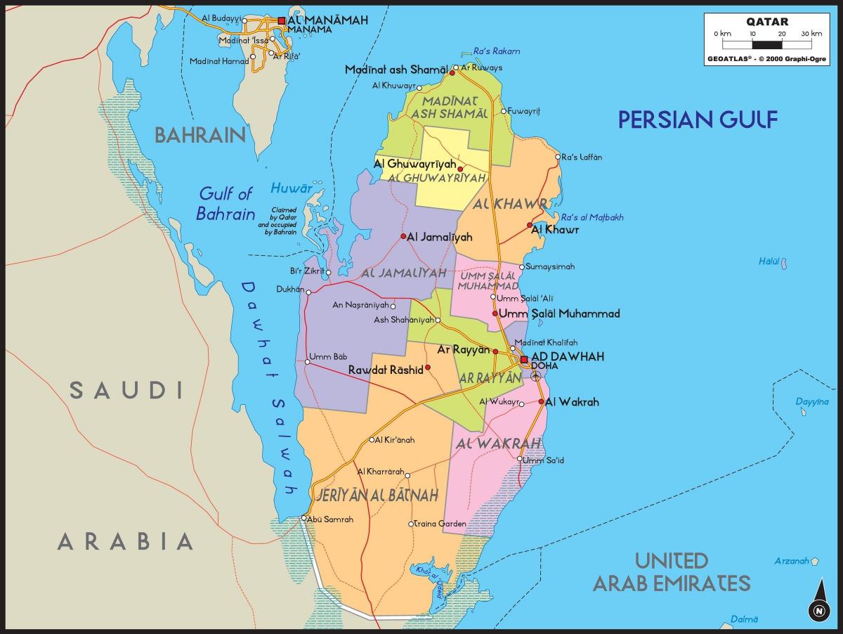
The Qatar states map shows all departments and regions of Qatar. States map of Qatar will allow you to know areas and cities of Qatar in Qatar. The Qatar states map is downloadable in PDF, printable and free.
Since 2015, Qatar has been divided into eight municipalities or states. A new municipality, Al Daayen, was created under Resolution No. 13, formed from parts of Umm Salal and Al Khawr; at the same time, Al Ghuwariyah was merged with Al Khawr; Al Jumaliyah was merged with Ar Rayyan; Jarayan al Batnah was split between Al Rayyan and Al Wakrah; and Mesaieed was merged with Al Wakrah as you can see in Qatar states map. In 2014, the western city of Al-Shahaniya split off from Al Rayyan Municipality to form its own municipality. For statistical purposes, the municipalities are further subdivided into 98 zones (as of 2015), which are in turn subdivided into districts and blocks, the latter being the lowest subdivision.
The Doha state since its inception with its various departments and units achieved many achievements and it took in mind the facilitating and expediting the completion of transactions and revisions in terms of municipal services, which has been done through the organized scientific planning , supporting these plans and programs, and setting all legislation and laws necessary to preserve these gains. Al Rayyan state was established under the municipal law of the year 1972 and the establishment of municipalities and dated 06/05/1392 AH 07/17/1972 M as its shown in Qatar states map. The building of Umm Slal municipality was opened on Saturday 16 Zo Alqeada in the year1394 , corresponding to 29/11/1974 AD city of Umm Slal under the auspices of the late Sheikh / Mohammed Bin Jabor Al Thani, Minister of Municipality and Urban Planning breviously and the presence of the late Mr. / Abdul Aziz Al-Ghanim Chairman of the Shura Council and the dignitaries of the region and their children.
Al Khor state was established under the law of year 1972, on 06/05/1319 AH 17/07/1972, which stipulates the establishment of new municipalities. Al Wakra state was established under the municipal law of the year 1972 and the establishment of municipalities and dated 06/05/1392 AH 07/17/1972 M. Al Daayen Municipality is located in the east of Um Qarn area on the coastal road near the bridge of Smisma Within the geographical boundaries include the following areas as its mentioned in Qatar states map: (for Obeib, Elaab, and Wadi Al Banat, Alkhash, Gunainat Guryan, Rawdat Al Hamama , valley wide, Sakhama, Alemsrouhah Reserve, Lucille, the Valley of Lusail, Umm Qarn, Daayen, Smisma, runoff, Tnbug, Jerry Matrooshi , the case of Hubert, the head of Alennk, Rahih, Wadi Ayrh). Al Shamal state was established under the municipal law of the year 1972 and the establishment of municipalities and dated 06/05/1392 H 07/17/1972G. On 15/1/2014 AD, the Reverent Cabinet approved the draft law of establishing Al Sheehaniya Municipality and draft law of identifying the geographical borders of Al Sheehaniya Municipality.